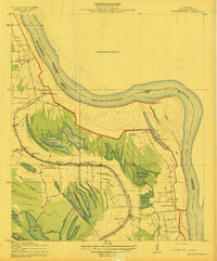
1909 Map of Millikens Bend
USGS Topo · Published 1909About this map
The massive oxbow of the Mississippi River defines this landscape in Madison Parish, where the river's shifting course created a complex network of oxbow lakes and backwater bayous. Numerous agricultural estates, including Hermean Plantation, Dalkeith Plantation, and Glen Mary Plantation, occupy the rich alluvial land bounded by the levee system. The local economy and social life of the early 20th century are reflected in small hubs like Millikens Bend and Duckport, supported by neighborhood centers such as Hughes Store and Huon Store.
Find a feature on this map
35 named features on this map. Tap any name to fly to it.
Don’t see what you’re looking for? This feature index may not catch every label — zoom into the map to look around manually.
Map Details
Editions of this 1909 Millikens Bend Map
3 editions found
Other maps of this area

1909 · Millikens Bend
USGS Topo · 1:24,000

1909 · Tallulah
USGS Topo · 1:24,000

1909 · Mound
USGS Topo · 1:24,000

1910 · Mound
USGS Topo · 1:31,680

1918 · Vicksburg
USGS Topo · 1:62,500

1939 · Onward
USGS Topo · 1:62,500

1939 · Talla Bena
USGS Topo · 1:62,500

1939 · Alsatia
USGS Topo · 1:62,500

1941 · Vicksburg
USGS Topo · 1:62,500

1955 · Jackson
USGS Topo · 1:250,000