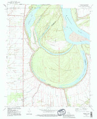
1994 Map of Millikin
USGS Topo · Published 1995About this map
Sarah Island and the massive curve of Pittman Island dominate this reach of the Mississippi River where the borders of Louisiana, Arkansas, and Mississippi converge. The landscape is defined by the hydrologic history of the river, seen in features like Bunchs Cutoff and the Old River channel. Along the western levees, a series of small agricultural settlements and crossroads like Millikin, Panola, and Shelburn follow the high ground. Local genealogy is well-preserved through numerous small burial grounds and congregations, including Panola Cem, King Solomon Cem, and Rose Hill Ch. The presence of the Landing Strip and drainage works like the Jack Falls Canal illustrate the mid-20th-century efforts to manage the fertile but flood-prone bottomlands for plantation-scale agriculture.
Find a feature on this map
29 named features on this map. Tap any name to fly to it.
Don’t see what you’re looking for? This feature index may not catch every label — zoom into the map to look around manually.
Map Details
Editions of this 1994 Millikin Map
This is the sole edition of this map. No revisions or reprints were ever made.
Other maps of this area

1909 · Baxter Bayou
USGS Topo · 1:24,000

1909 · Lake Providence
USGS Topo · 1:24,000

1909 · Wilsons Point
USGS Topo · 1:24,000

1909 · Millikin
USGS Topo · 1:24,000

1909 · Ashton Bridge
USGS Topo · 1:24,000

1911 · Lake Providence
USGS Topo · 1:31,680

1911 · Baxter Bayou
USGS Topo · 1:24,000

1912 · Ashton Bridge
USGS Topo · 1:31,680

1913 · Wilson Point
USGS Topo · 1:31,680

1914 · Baxter Bayou
USGS Topo · 1:31,680