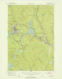
1951 Map of Millinocket
USGS Topo · Published 1953About this map
The industrial and river landscape of Millinocket and East Millinocket dominates this 1951 survey, defined by the extensive water management of the East Branch Penobscot River. The area’s reliance on the river and the Bangor and Aroostook railroad is evident in the sprawling network of flowages and ponds, including Dolby Pond and Ferguson Lake.
Find a feature on this map
91 named features on this map. Tap any name to fly to it.
Don’t see what you’re looking for? This feature index may not catch every label — zoom into the map to look around manually.
Map Details
Editions of this 1951 Millinocket Map
4 editions found

Other maps of this area

1920 · Winn
USGS Topo · 1:62,500

1927 · Katahdin
USGS Topo · 1:48,000

1930 · Katahdin
USGS Topo · 1:62,500

1940 · Sherman
USGS Topo · 1:62,500

1940 · Mattawamkeag
USGS Topo · 1:62,500

1942 · Lincoln
USGS Topo · 1:62,500

1942 · Mattawamkeag
USGS Topo · 1:62,500

1942 · Sherman
USGS Topo · 1:62,500

1947 · Schoodic
USGS Topo · 1:62,500

1949 · Schoodic
USGS Topo · 1:62,500