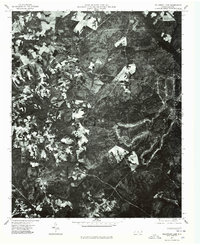
1976 Map of Millstone Lake
USGS Topo · Published 1978About this map
Millstone Lake sits at the heart of this orthophotomap, which offers a clear visual record of the land use patterns in Richmond County during the mid-1970s. Unlike a traditional line-drawn topographic map, this photographic survey reveals the precise texture of the forest cover and the intricate geometry of agricultural clearings. The winding course of Beaver Creek carves through the dense woodlands, highlighting the natural drainage systems that dictated the placement of local roads and farmsteads. By examining the varied density of the timber and the sharp boundaries of the fields, researchers can interpret the mid-century timbering practices and rural development of this North Carolina landscape.
Find a feature on this map
2 named features on this map. Tap any name to fly to it.
Don’t see what you’re looking for? This feature index may not catch every label — zoom into the map to look around manually.
Map Details
Editions of this 1976 Millstone Lake Map
This is the sole edition of this map. No revisions or reprints were ever made.
Other maps of this area

1942 · Troy
USGS Topo · 1:125,000

1942 · Rockingham
USGS Topo · 1:125,000

1949 · Millstone Lake
USGS Topo · 1:24,000

1949 · West End
USGS Topo · 1:24,000

1949 · Hoffman
USGS Topo · 1:24,000

1949 · Marston
USGS Topo · 1:24,000

1949 · Hamlet
USGS Topo · 1:24,000

1949 · Hamlet
USGS Topo · 1:62,500

1949 · Jackson Springs
USGS Topo · 1:62,500

1950 · Norman
USGS Topo · 1:24,000