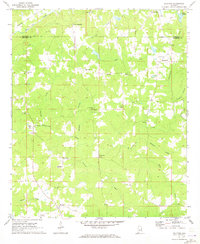
1969 Map of Milltown
USGS Topo · Published 1973About this map
Milltown serves as the focal point of this Chambers County landscape, situated where the County High Sch and Milltown Cem anchor the local community. The terrain is defined by the winding course of Chikasanoxee Creek and its many tributaries, including Williams Creek and Mathews Branch. Small crossroads and rural gathering places like Pooles Crossroad, Clackville, and Penton are scattered across the quadrangle, illustrating the decentralized settlement pattern of eastern Alabama in the late 1960s.
Find a feature on this map
36 named features on this map. Tap any name to fly to it.
Don’t see what you’re looking for? This feature index may not catch every label — zoom into the map to look around manually.
Map Details
Editions of this 1969 Milltown Map
2 editions found
Other maps of this area

1891 · Ashland
USGS Topo · 1:125,000

1899 · Wedowee
USGS Topo · 1:125,000

1902 · Wedowee
USGS Topo · 1:125,000

1906 · Dadeville
USGS Topo · 1:125,000

1907 · Opelika
USGS Topo · 1:125,000

1909 · Opelika
USGS Topo · 1:125,000

1953 · Atlanta
USGS Topo · 1:250,000

1955 · Phenix City
USGS Topo · 1:250,000

1957 · Phenix City
USGS Topo · 1:250,000

1957 · Atlanta
USGS Topo · 1:250,000