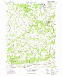
1968 Map of Millville
USGS Topo · Published 1978About this map
The borough of Millville serves as the focal point for this survey of the northern Susquehanna River valley borderlands, where agriculture and small settlements intersect along the banks of Little Fishing Creek. By the mid-1970s, the landscape reflects a long-established rural network of country roads and rail infrastructure, most notably the Conrail line passing through Eyers Grove and Mud Creek. The distribution of family-centered landmarks like Dutch Hill Ch and Longs Ch suggests a deeply rooted community structure maintained well into the modern era.
Find a feature on this map
36 named features on this map. Tap any name to fly to it.
Don’t see what you’re looking for? This feature index may not catch every label — zoom into the map to look around manually.
Map Details
Editions of this 1968 Millville Map
3 editions found
Other maps of this area

1889 · Catawissa
USGS Topo · 1:62,500

1892 · Catawissa
USGS Topo · 1:62,500

1892 · Shamokin
USGS Topo · 1:62,500

1893 · Shamokin
USGS Topo · 1:62,500

1894 · Catawissa
USGS Topo · 1:62,500

1894 · Bloomsburg
USGS Topo · 1:62,500

1935 · Hughesville
USGS Topo · 1:62,500

1943 · Shamokin
USGS Topo · 1:62,500

1947 · Bloomsburg
USGS Topo · 1:24,000
1947 · Catawissa
USGS Topo · 1:24,000
Featured Places
- Greenwood Township, PA
- Millville, PA
- Pine Township, PA
- East Millville, PA
- Eyers Grove, Greenwood Township