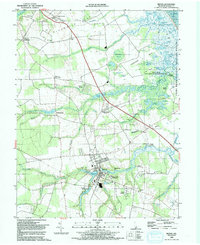
1992 Map of Milton
USGS Topo · Published 1992About this map
Milton serves as the focal point of this Delaware coastal plain landscape, where the Broadkill River meets the intricate wetlands of the Atlantic shore. The town is surrounded by a patchwork of small crossroads communities and residential developments like Argo Corners, Su-Sax Acres, and Cave Colony. The eastern edge of the map is dominated by the complex aquatic environment of the Prime Hook National Wildlife Refuge, featuring a dense network of water bodies such as Slaughter Pond, Caleb Pond, and Poplar Woods Pond.
Find a feature on this map
90 named features on this map. Tap any name to fly to it.
Don’t see what you’re looking for? This feature index may not catch every label — zoom into the map to look around manually.
Map Details
Editions of this 1992 Milton Map
This is the sole edition of this map. No revisions or reprints were ever made.
Other maps of this area

1917 · Millsboro
USGS Topo · 1:62,500

1918 · Cedar Creek
USGS Topo · 1:62,500

1918 · Rehoboth
USGS Topo · 1:62,500

1918 · Cape Henlopen
USGS Topo · 1:62,500

1919 · Cedar Creek
USGS Topo · 1:62,500

1937 · Cape Henlopen
USGS Topo · 1:62,500

1938 · Cedar Creek
USGS Topo · 1:62,500

1938 · Millsboro
USGS Topo · 1:62,500

1938 · Rehoboth
USGS Topo · 1:62,500

1943 · Fairmount
USGS Topo · 1:24,000