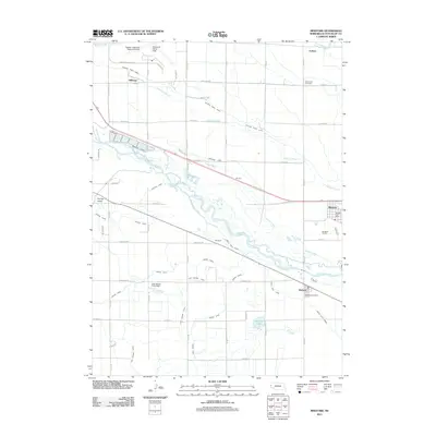
2011 Map of Minatare
USGS Topo · Published 2011About this map
The North Platte River defines the central axis of this landscape, its braided channels flanked by an intricate network of irrigation infrastructure essential to the Scotts Bluff County agriculture. Small communities such as Minatare and Melbeta anchor the region, both retaining their respective post offices as local hubs. The extensive system of man-made waterways, including the Winters Creek Canal, Minatare Canal, and Fort Laramie Canal, illustrates the scale of water management required to support the local economy. In the northern section, the Western Nebraska Regional Airport, also known as William B Heilig Field, serves as a modern transportation landmark alongside the smaller settlement of Hillerage. Cultural landmarks like the East Lawn Cemetery and the Minatare Feedlot provide specific points of interest for genealogists and local historians tracking the development of the valley's cattle and farming industries.
Find a feature on this map
55 named features on this map. Tap any name to fly to it.
Don’t see what you’re looking for? This feature index may not catch every label — zoom into the map to look around manually.
Map Details
Editions of this 2011 Minatare Map
This is the sole edition of this map. No revisions or reprints were ever made.
Other maps of this area

1898 · Scotts Bluff
USGS Topo · 1:125,000

1898 · Camp Clarke
USGS Topo · 1:125,000

1954 · Scottsbluff
USGS Topo · 1:250,000

1958 · Scottsbluff
USGS Topo · 1:250,000

1963 · Scottsbluff South
USGS Topo · 1:24,000

1963 · Scottsbluff North
USGS Topo · 1:24,000

1965 · Minatare
USGS Topo · 1:24,000
1965 · Lake Alice
USGS Topo · 1:24,000

1965 · Bayard SW
USGS Topo · 1:24,000

1965 · McGrew
USGS Topo · 1:24,000