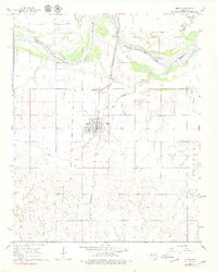
1966 Map of Minco
USGS Topo · Published 1979About this map
Minco serves as the primary hub of this 1960s landscape, situated along the north-south corridor of the Chicago Rock Island and Pacific railroad and U.S. Route 81. The topography is defined by the braided path of the Canadian River to the north, which forms a natural boundary between Grady and Canadian counties. An important historical boundary is preserved here, as the map clearly delineates the Old Oklahoma Territory Line and the Old Indian Territory Line, reflecting the complex administrative heritage of the region.
Find a feature on this map
20 named features on this map. Tap any name to fly to it.
Don’t see what you’re looking for? This feature index may not catch every label — zoom into the map to look around manually.
Map Details
Editions of this 1966 Minco Map
2 editions found
Other maps of this area

1893 · Buggy Creek
USGS Topo · 1:62,500

1893 · Minco
USGS Topo · 1:62,500

1904 · Chickasha
USGS Topo · 1:125,000

1945 · Anadarko
USGS Topo · 1:62,500

1954 · Oklahoma City
USGS Topo · 1:250,000

1955 · Clinton
USGS Topo · 1:250,000

1957 · Clinton
USGS Topo · 1:250,000

1957 · Oklahoma City
USGS Topo · 1:250,000

1963 · Oklahoma City
USGS Topo · 1:250,000
1966 · Minco NE
USGS Topo · 1:24,000