
1894 Map of Minden
USGS Topo · Published 1908About this map
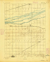
Platte River braiding and channelization dominate the northern half of this Central Nebraska survey, creating a complex network of named islands and waterways. The North Channel and South Channel wrap around substantial landmasses like Grand Island, Fort Farm Island, and Clark Island, defining the boundary between Buffalo and Kearney Counties. These river dynamics dictated the placement of early settlements and infrastructure, forcing the Union Pacific R.R. to the north through Gibbon and the Burlington and Missouri River R.R. to the south through Newark and Lowell.
Find a feature on this map
32 named features on this map. Tap any name to fly to it.
Don’t see what you’re looking for? This feature index may not catch every label — zoom into the map to look around manually.
Map Details
Editions of this 1894 Minden Map
2 editions found
Historical Maps of Minden Through Time
1 maps found