
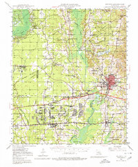
1947 Map of Minden
USGS Topo · Published 1964About this map
The Louisiana Ordnance Plant dominates the central landscape of this Webster Parish survey, reflecting the era's significant industrial and military presence between Doyline and Minden. To the west, the Bellevue Oilfield and numerous underground pipe lines indicate the region's active petroleum economy. Transportation is anchored by the Kansas City Southern and Illinois Central railroads, which connect established towns like Sibley and Haughton to the wider trade network.
Find a feature on this map
77 named features on this map. Tap any name to fly to it.
Don’t see what you’re looking for? This feature index may not catch every label — zoom into the map to look around manually.
Map Details
Editions of this 1947 Minden Map
2 editions found
Other maps of this area

1922 · Sarepta
USGS Topo · 1:62,500

1924 · Sarepta
USGS Topo · 1:62,500

1932 · Bossier SE
USGS Topo · 1:31,680

1932 · Bossier NE
USGS Topo · 1:31,680

1938 · Arnsberg
USGS Topo · 1:31,680

1947 · Ringgold
USGS Topo · 1:62,500

1948 · Bossier City
USGS Topo · 1:62,500

1948 · Caspiana
USGS Topo · 1:62,500

1948 · Jamestown
USGS Topo · 1:62,500

1949 · Jamestown
USGS Topo · 1:62,500