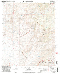
2004 Map of Mine Mountain
USGS Topo · Published 2007About this map
The Mazatzal Mountains dominate the northeastern portion of this topographic survey, marking a significant transition in the central Arizona landscape. Much of the terrain is protected within the Four Peaks Wilderness and the Soldier Camp Wilderness, preserving a network of seasonal water sources and peaks that define the Tonto National Forest. The map captures the meeting point of the Gila and Maricopa county lines, a boundary that runs through the high country near Pine Mountain.
Find a feature on this map
29 named features on this map. Tap any name to fly to it.
Don’t see what you’re looking for? This feature index may not catch every label — zoom into the map to look around manually.
Map Details
Editions of this 2004 Mine Mountain Map
This is the sole edition of this map. No revisions or reprints were ever made.
Other maps of this area

1904 · Ft. McDowell
USGS Topo · 1:62,500

1906 · Ft. McDowell
USGS Topo · 1:62,500

1907 · Roosevelt
USGS Topo · 1:125,000

1909 · Four Peaks
USGS Topo · 1:125,000

1912 · Roosevelt
USGS Topo · 1:125,000

1930 · Cave Creek
USGS Topo · 1:125,000

1939 · Cave Creek
USGS Topo · 1:125,000

1954 · Mesa
USGS Topo · 1:250,000

1957 · Mesa
USGS Topo · 1:250,000

1958 · Mesa
USGS Topo · 1:250,000