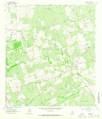
1963 Map of Mineral
USGS Topo · Published 1965About this map
Mineral stands as the central settlement in this South Texas landscape, located at the confluence of several active energy production zones. The mid-century development of the region is clearly defined by an expansive network of petroleum and gas extraction, with the Plummer Oil Field and Cannan Oil Field dominating the northern terrain, while the Mineral Gas Field and Goree Oil Field span the south. This industrial activity is woven through a topography carved by San Domingo Creek and Toro Creek, illustrating the coexistence of ranching country and the Texas oil boom.
Find a feature on this map
22 named features on this map. Tap any name to fly to it.
Don’t see what you’re looking for? This feature index may not catch every label — zoom into the map to look around manually.
Map Details
Editions of this 1963 Mineral Map
2 editions found
Other maps of this area

1920 · Mikeska
USGS Topo · 1:125,000

1927 · Oakville
USGS Topo · 1:62,500

1936 · Pettus
USGS Topo · 1:62,500

1953 · Crystal City
USGS Topo · 1:250,000

1953 · Beeville
USGS Topo · 1:250,000

1954 · Fleming
USGS Topo · 1:62,500

1955 · Crystal City
USGS Topo · 1:250,000

1956 · Suniland
USGS Topo · 1:62,500

1956 · Beeville
USGS Topo · 1:250,000

1956 · Pettus
USGS Topo · 1:62,500