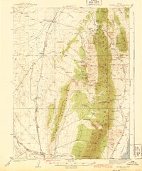
1943 Map of Mineral Hill
USGS Topo · Published 1943About this map
The Eureka Nevada (Abandoned) railroad corridor cuts through this Great Basin landscape, marking a transition in the region's transport network as it appeared during the 1937 survey. The high terrain of the Sulphur Spring Range and the Diamond Mountains dominates the geography, dotted with isolated family operations such as the Bruffey Ranch, Plummer Ranch, and Flynn Ranch.
Find a feature on this map
67 named features on this map. Tap any name to fly to it.
Don’t see what you’re looking for? This feature index may not catch every label — zoom into the map to look around manually.
Map Details
Editions of this 1943 Mineral Hill Map
2 editions found
Other maps of this area

1926 · Roberts Mountains
USGS Topo · 1:250,000

1929 · Roberts Mountains
USGS Topo · 1:250,000

1934 · Jiggs
USGS Topo · 1:125,000

1937 · Mineral Hill
USGS Topo · 1:48,000

1937 · Jiggs
USGS Topo · 1:125,000

1943 · Mineral Hill
USGS Topo · 1:62,500

1949 · Garden Valley
USGS Topo · 1:62,500

1949 · Roberts Creek Mtn
USGS Topo · 1:62,500

1951 · Roberts Creek Mtn
USGS Topo · 1:62,500

1951 · Garden Valley
USGS Topo · 1:62,500