1956 Map of Mineral King
USGS Topo · Published 1963About this map
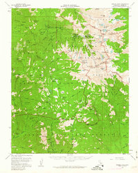
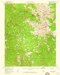
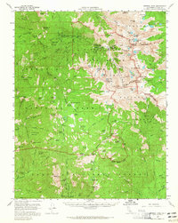
Silver City and the historic settlement of Mineral King anchor this mid-century survey of the high Sierras. The map details a landscape defined by its giant Sierra Redwoods, including the Oriole Grove, Atwell Grove, and Dillonwood Grove. These groves are interspersed with evidence of early timber and ranger activity, such as the Atwell Mill Ranger Station and the Dillon Mill Site. High-altitude meadows like Hockett Meadows and Cahoon Meadow are connected by a network of primitive routes, including the Hockett Trail and Mineral King Trail. The presence of the Cahoon Rock Lookout and various backcountry stations like Quinn Ranger Station reflects the active management of the Sequoia National Park and Sequoia National Forest during the 1950s. The drainage basins of the East Fork Kaweah River and South Fork Kaweah River are meticulously mapped, showing numerous alpine lakes including Eagle Lake and the Big Five Lakes.
Find a feature on this map
135 named features on this map. Tap any name to fly to it.
Don’t see what you’re looking for? This feature index may not catch every label — zoom into the map to look around manually.
Map Details
Editions of this 1956 Mineral King Map
3 editions found
Other maps of this area

1903 · Tehipite
USGS Topo · 1:125,000

1904 · Kaweah
USGS Topo · 1:125,000

1905 · Tehipite
USGS Topo · 1:125,000

1905 · Olancha
USGS Topo · 1:125,000

1907 · Olancha
USGS Topo · 1:125,000

1907 · Mt. Whitney
USGS Topo · 1:125,000

1909 · Kaweah
USGS Topo · 1:125,000

1919 · Mt. Whitney
USGS Topo · 1:125,000

1937 · Mt. Whitney
USGS Topo · 1:125,000

1937 · Kaweah
USGS Topo · 1:125,000