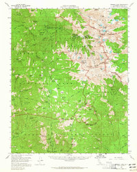
1956 Map of Mineral King
USGS Topo · Published 1965About this map
Silver City and the historic settlement of Mineral King serve as the primary human outposts in this high-elevation landscape within Sequoia National Park. The map documents a transition from early industrial extraction to preservation, evidenced by the presence of Dillon Mill alongside numerous protected giant sequoia stands like Atwell Grove, Oriole Grove, and Garfield Grove. The East Fork Kaweah River and South Fork Kaweah River carve through steep topography, where access was largely restricted to routes like the Hockett Trail.
Find a feature on this map
160 named features on this map. Tap any name to fly to it.
Don’t see what you’re looking for? This feature index may not catch every label — zoom into the map to look around manually.
Map Details
Editions of this 1956 Mineral King Map
3 editions found

Other maps of this area

1903 · Tehipite
USGS Topo · 1:125,000

1904 · Kaweah
USGS Topo · 1:125,000

1905 · Tehipite
USGS Topo · 1:125,000

1905 · Olancha
USGS Topo · 1:125,000

1907 · Olancha
USGS Topo · 1:125,000

1907 · Mt. Whitney
USGS Topo · 1:125,000

1909 · Kaweah
USGS Topo · 1:125,000

1919 · Mt. Whitney
USGS Topo · 1:125,000

1937 · Mt. Whitney
USGS Topo · 1:125,000

1937 · Kaweah
USGS Topo · 1:125,000