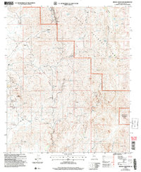
2004 Map of Mineral Mountain
USGS Topo · Published 2007About this map
Mining history dominates this Pinal County landscape, centered on the Reymert settlement location and the nearby Reymert Mine. The desert terrain is deeply etched by Box Canyon and Alamo Canyon, where numerous extraction points like the Silver Bell Mine, Martinez Mine, and Oklahoma Mine reflect a legacy of prospecting. While the eastern portion is protected within the White Canyon Wilderness, the central and northern areas belong to the Tonto National Forest. Transportation through this arid environment relies on historic routes such as Reymert Road and Mineral Mountain Road, while the modern Arizona Trail traverses the eastern slopes. Vital water sources are scarce, appearing as isolated features like Reymert Spring, Alamo No. 2 Tank, and Filoria Spring, which supported the region's scattered mining operations.
Find a feature on this map
40 named features on this map. Tap any name to fly to it.
Don’t see what you’re looking for? This feature index may not catch every label — zoom into the map to look around manually.
Map Details
Editions of this 2004 Mineral Mountain Map
This is the sole edition of this map. No revisions or reprints were ever made.
Other maps of this area

1900 · Florence
USGS Topo · 1:125,000

1902 · Florence
USGS Topo · 1:125,000

1948 · Superior
USGS Topo · 1:62,500

1948 · Superior
USGS Topo · 1:24,000

1948 · Picketpost Mtn
USGS Topo · 1:24,000

1949 · Superior
USGS Topo · 1:24,000

1949 · Picketpost Mtn
USGS Topo · 1:24,000

1954 · Mesa
USGS Topo · 1:250,000

1957 · Mesa
USGS Topo · 1:250,000

1958 · Mesa
USGS Topo · 1:250,000