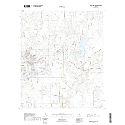
2019 Map of Mineral Wells East
USGS Topo · Published 2019About this map
Mineral Wells serves as the focal point of this North Texas survey, where the urban grid is constrained by the distinct rises of East Mtn and West Mtn. The landscape to the east transitions into the varied terrain of the Palo Pinto and Parker county line, defined by the drainage of Rock Creek and the expansive Lake Mineral Wells. This 2019 data illustrates the modern footprint of the area, including the Mineral Wells Airport and small outlying communities such as Sturdivant, Cool, and Millsap. Genealogists will find several notable burial grounds documented, including Staggs Prairie Cem, Woodland Park Cem, and the Old Millsap Cem. The map traces the historical path of the Lake Mineral Wells State Trailway, showing how former transportation corridors have been repurposed for contemporary use amidst the watershed of Wilson Cr and Whatley Cr.
Find a feature on this map
247 named features on this map. Tap any name to fly to it.
Don’t see what you’re looking for? This feature index may not catch every label — zoom into the map to look around manually.
Map Details
Editions of this 2019 Mineral Wells East Map
This is the sole edition of this map. No revisions or reprints were ever made.
Other maps of this area

1891 · Weatherford
USGS Topo · 1:125,000

1891 · Palo Pinto
USGS Topo · 1:125,000

1893 · Weatherford
USGS Topo · 1:125,000

1918 · Palo Pinto
USGS Topo · 1:125,000

1924 · Palo Pinto 1-b
USGS Topo · 1:48,000

1925 · Palo Pinto 4-b
USGS Topo · 1:48,000

1927 · Mineral Wells
USGS Topo · 1:62,500

1931 · Dennis
USGS Topo · 1:62,500

1931 · Santo
USGS Topo · 1:62,500

1954 · Dallas
USGS Topo · 1:250,000