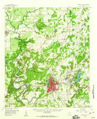
1959 Map of Mineral Wells
USGS Topo · Published 1960About this map
The Brazos River snakes through the western portion of this Palo Pinto County landscape, defining a series of dramatic geographic loops including Moffitt Bend, Ballenger Bend, and Dog Bend. The city of Mineral Wells serves as the primary hub, showing a developed street grid and specialized sites like the Lamar Sch and the Municipal Airport. This era is heavily defined by the military footprint of Camp Wolters, which features an extensive network of helicopter stage fields and the residential development at Wolters Village.
Find a feature on this map
82 named features on this map. Tap any name to fly to it.
Don’t see what you’re looking for? This feature index may not catch every label — zoom into the map to look around manually.
Map Details
Editions of this 1959 Mineral Wells Map
2 editions found
Other maps of this area

1891 · Weatherford
USGS Topo · 1:125,000

1891 · Palo Pinto
USGS Topo · 1:125,000

1893 · Weatherford
USGS Topo · 1:125,000

1918 · Palo Pinto
USGS Topo · 1:125,000

1924 · Palo Pinto 2-a
USGS Topo · 1:48,000

1924 · Palo Pinto 1-b
USGS Topo · 1:48,000

1925 · Palo Pinto 4-b
USGS Topo · 1:48,000

1927 · Pickwick
USGS Topo · 1:62,500

1927 · Mineral Wells
USGS Topo · 1:62,500

1931 · Dennis
USGS Topo · 1:62,500