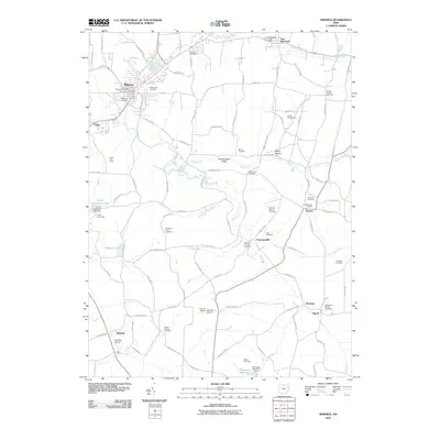
2010 Map of Minerva
USGS Topo · Published 2010About this map
Sandy Creek and the Still Fork define the drainage of this eastern Ohio landscape, where the village of Minerva sits at the confluence of several vital waterways. This 2010 survey highlights a region dotted with rural settlements and numerous ancestral burial grounds, including the Still Fork Church Cemetery and West Lawn Cemetery. The map captures the agricultural and small-town character of the area, featuring isolated communities like Augusta, Pattersonville, and East Rochester.
Find a feature on this map
106 named features on this map. Tap any name to fly to it.
Don’t see what you’re looking for? This feature index may not catch every label — zoom into the map to look around manually.
Map Details
Editions of this 2010 Minerva Map
This is the sole edition of this map. No revisions or reprints were ever made.
Other maps of this area

1905 · Salineville
USGS Topo · 1:62,500

1909 · Alliance
USGS Topo · 1:62,500

1909 · Lisbon
USGS Topo · 1:62,500

1910 · Carrollton
USGS Topo · 1:62,500

1912 · Carrollton
USGS Topo · 1:62,500

1951 · Canton
USGS Topo · 1:250,000

1953 · Canton
USGS Topo · 1:250,000

1957 · Canton
USGS Topo · 1:250,000
1959 · Dellroy
USGS Topo · 1:24,000
1959 · Hanoverton
USGS Topo · 1:24,000