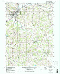
1994 Map of Minerva
USGS Topo · Published 1998About this map
Minerva serves as the focal point of this regional study, situated at the crossroads of Stark, Columbiana, and Carroll counties. The landscape is defined by the winding course of Sandy Creek and the Still Fork, where several small settlements like East Rochester and Augusta are anchored by long-standing community institutions. Genealogists will find a wealth of burial sites across the rolling terrain, from the Plains Cem in the north to the Stuller Cem in the south, reflecting generations of rural settlement.
Find a feature on this map
52 named features on this map. Tap any name to fly to it.
Don’t see what you’re looking for? This feature index may not catch every label — zoom into the map to look around manually.
Map Details
Editions of this 1994 Minerva Map
This is the sole edition of this map. No revisions or reprints were ever made.
Other maps of this area

1905 · Salineville
USGS Topo · 1:62,500

1909 · Alliance
USGS Topo · 1:62,500

1909 · Lisbon
USGS Topo · 1:62,500

1910 · Carrollton
USGS Topo · 1:62,500

1912 · Carrollton
USGS Topo · 1:62,500

1951 · Canton
USGS Topo · 1:250,000

1953 · Canton
USGS Topo · 1:250,000

1957 · Canton
USGS Topo · 1:250,000
1959 · Dellroy
USGS Topo · 1:24,000
1959 · Hanoverton
USGS Topo · 1:24,000