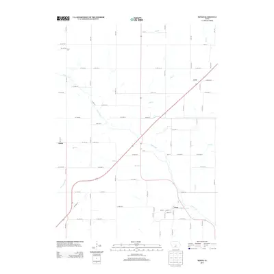
2013 Map of Mingo
USGS Topo · Published 2013About this map
Mingo serves as a primary settlement in this part of Jasper County, where the street grid of East and West Main Streets meets the natural path of Indian Creek. The surrounding landscape is defined by its drainage network, with Wolf Cr and Mud Cr carving paths through the northern sections, while Byers Br and Clear Cr cross the southern agricultural fields. Smaller hamlets and rural centers like Clyde, Peoria City, and Farrar are scattered across the quadrangle, connected by a structured grid of county roads and highways. The presence of Ditch Number 38 in the southwest highlights the intentional modification of the water table for farming. This 2013 survey illustrates the enduring rural character of the region, showing how contemporary transportation corridors such as Co HWY-f17 and State Highway 117 integrate with the historic township boundaries and family-farm road systems.
Find a feature on this map
72 named features on this map. Tap any name to fly to it.
Don’t see what you’re looking for? This feature index may not catch every label — zoom into the map to look around manually.
Map Details
Editions of this 2013 Mingo Map
This is the sole edition of this map. No revisions or reprints were ever made.
Other maps of this area

1930 · Mitchellville
USGS Topo · 1:62,500

1954 · Des Moines
USGS Topo · 1:250,000

1956 · Des Moines
USGS Topo · 1:250,000

1957 · Des Moines
USGS Topo · 1:250,000

1965 · Colfax
USGS Topo · 1:24,000

1969 · Des Moines
USGS Topo · 1:250,000
1972 · Altoona
USGS Topo · 1:24,000
1972 · Mitchellville
USGS Topo · 1:24,000
1972 · Loring
USGS Topo · 1:24,000

1975 · Mingo
USGS Topo · 1:24,000