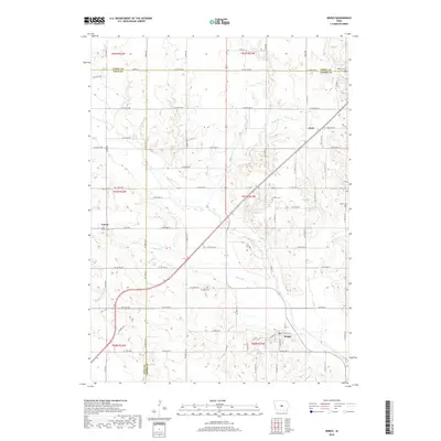
2018 Map of Mingo
USGS Topo · Published 2018About this map
Mingo serves as the primary hub in this corner of Jasper County, situated where Clear Cr meanders through the southern landscape. The map illustrates a strictly organized agricultural grid, punctuated by small settlements like Clyde and Farrar, which maintain their distinct identities amidst the vast sections of Poweshiek Township. The terrain is defined by its water systems, including Wolf Cr and Byers Br, while Ditch Number 38 indicates a history of managed drainage to support local farming.
Find a feature on this map
71 named features on this map. Tap any name to fly to it.
Don’t see what you’re looking for? This feature index may not catch every label — zoom into the map to look around manually.
Map Details
Editions of this 2018 Mingo Map
This is the sole edition of this map. No revisions or reprints were ever made.
Other maps of this area

1930 · Mitchellville
USGS Topo · 1:62,500

1954 · Des Moines
USGS Topo · 1:250,000

1956 · Des Moines
USGS Topo · 1:250,000

1957 · Des Moines
USGS Topo · 1:250,000

1965 · Colfax
USGS Topo · 1:24,000

1969 · Des Moines
USGS Topo · 1:250,000
1972 · Altoona
USGS Topo · 1:24,000
1972 · Mitchellville
USGS Topo · 1:24,000
1972 · Loring
USGS Topo · 1:24,000

1975 · Mingo
USGS Topo · 1:24,000