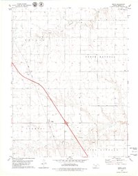
1979 Map of Mingo
USGS Topo · Published 1979About this map
Mingo and Altair define the settlement pattern of this High Plains landscape in Thomas County, situated between the branching headwaters of a major regional waterway. The area is bisected by the Union Pacific railroad, which runs northwest to southeast across the terrain of Morgan and Summers townships. This 1970s survey captures the region just as Interstate 70 was becoming a primary corridor, running parallel to the older rail line.
Find a feature on this map
14 named features on this map. Tap any name to fly to it.
Don’t see what you’re looking for? This feature index may not catch every label — zoom into the map to look around manually.
Map Details
Editions of this 1979 Mingo Map
This is the sole edition of this map. No revisions or reprints were ever made.
Other maps of this area

1943 · Colby
USGS Topo · 1:62,500

1954 · Goodland
USGS Topo · 1:250,000

1956 · Goodland
USGS Topo · 1:250,000

1957 · Goodland
USGS Topo · 1:250,000

1967 · Colby SE
USGS Topo · 1:24,000

1967 · Colby
USGS Topo · 1:24,000

1972 · Winona NE
USGS Topo · 1:24,000

1979 · Oakley North
USGS Topo · 1:24,000
1979 · Gem
USGS Topo · 1:24,000
1979 · Spica
USGS Topo · 1:24,000