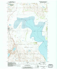
1994 Map of Minnewaukan East
USGS Topo · Published 1995About this map
Minnewaukan sits at the western edge of this mid-1990s survey, overlooking the complex shorelines of West Bay and Devils Lake. The landscape is a mosaic of prairie wetlands and higher ground, featuring prominent landmarks like Sams Hill and the wooded terrain of Grahams Island to the east. To the north, the National Waterfowl Production Area highlights the region's importance as a migratory habitat, while the southern portion of the quadrangle is occupied by the Sioux Indian Reservation.
Find a feature on this map
15 named features on this map. Tap any name to fly to it.
Don’t see what you’re looking for? This feature index may not catch every label — zoom into the map to look around manually.
Map Details
Editions of this 1994 Minnewaukan East Map
This is the sole edition of this map. No revisions or reprints were ever made.
Other maps of this area

1931 · Oberon
USGS Topo · 1:62,500

1932 · Flora
USGS Topo · 1:62,500

1932 · Grahams Island
USGS Topo · 1:62,500

1950 · Grahams Island
USGS Topo · 1:62,500

1950 · Oberon
USGS Topo · 1:62,500

1951 · Crow Hill
USGS Topo · 1:24,000

1951 · Oberon
USGS Topo · 1:24,000

1951 · Grahams Island
USGS Topo · 1:24,000

1951 · Tilden
USGS Topo · 1:24,000

1951 · Minnewaukan East
USGS Topo · 1:24,000