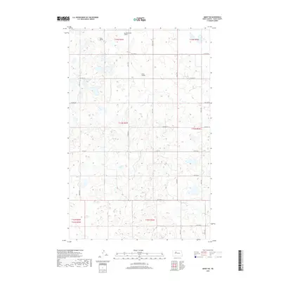
2018 Map of Minot SW
USGS Topo · Published 2018About this map
Twin Buttes rises as a distinct topographical marker in this section of Ward County, north of the small drainage channels that define the local prairie hydrology. The landscape is marked by a strict section-line grid of rural roads, including Co Hwy 20 and Township Rd, which organize the agricultural territory within various townships like t153n r84w. Water management and natural drainage are indicated by features such as Second Larson Coulee and Kemp Coulee, which cut through the undulating plains. This 2018 survey illustrates the persistent importance of the Public Land Survey System in North Dakota, where the intersections of routes like 121st Ave SW and 100th St SW continue to delineate the boundaries of individual farmsteads and rural properties.
Find a feature on this map
24 named features on this map. Tap any name to fly to it.
Don’t see what you’re looking for? This feature index may not catch every label — zoom into the map to look around manually.
Map Details
Editions of this 2018 Minot SW Map
This is the sole edition of this map. No revisions or reprints were ever made.
Other maps of this area

1928 · Minot
USGS Topo · 1:62,500

1948 · Minot NW
USGS Topo · 1:24,000

1949 · Minot NW
USGS Topo · 1:24,000

1949 · Minot
USGS Topo · 1:24,000

1954 · Minot
USGS Topo · 1:250,000

1954 · McClusky
USGS Topo · 1:250,000

1958 · McClusky
USGS Topo · 1:250,000

1958 · Minot
USGS Topo · 1:250,000
1966 · Minot
USGS Topo · 1:24,000

1980 · Minot
USGS Topo · 1:100,000