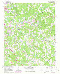
1971 Map of Mint Hill
USGS Topo · Published 1981About this map
The expanding eastern edge of Charlotte meets the rural-to-suburban transition of eastern Mecklenburg County in the late 1960s and early 1970s. This survey records a landscape where older agricultural roots and community landmarks like the Philadelphia Ch and Bain Sch in Mint Hill coexist with the burgeoning residential developments of Marlwood Acres and Idlewild. The terrain is characterized by numerous small waterways, including McAlpine Creek and Caldwell Creek, which intersect the path of the Norfolk Southern and Seaboard Coast Line railroads. Purple overprinting on this document indicates significant urban expansion between the 1971 field check and the 1980 map revision, particularly around Hickory Grove and Wilgrove. Local institutions such as Independence High Sch and Camp Stewart provide clear points of reference for tracing the post-war growth of this Piedmont region.
Find a feature on this map
69 named features on this map. Tap any name to fly to it.
Don’t see what you’re looking for? This feature index may not catch every label — zoom into the map to look around manually.
Map Details
Editions of this 1971 Mint Hill Map
Other maps of this area

1905 · Charlotte
USGS Topo · 1:48,000

1907 · Charlotte
USGS Topo · 1:62,500

1941 · Charlotte
USGS Topo · 1:125,000

1942 · Charlotte
USGS Topo · 1:125,000

1948 · Derita
USGS Topo · 1:24,000

1948 · Charlotte East
USGS Topo · 1:24,000

1949 · Charlotte East
USGS Topo · 1:24,000

1949 · Harrisburg
USGS Topo · 1:24,000

1949 · Wilgrove
USGS Topo · 1:24,000

1949 · Midland
USGS Topo · 1:24,000