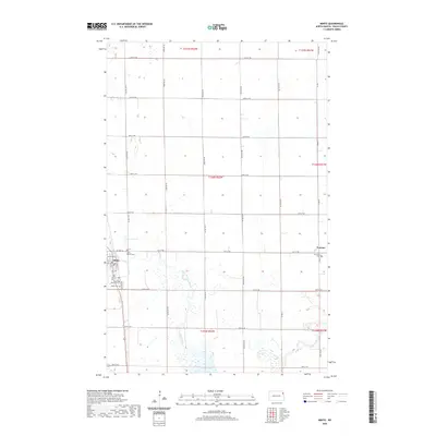
2020 Map of Minto
USGS Topo · Published 2020About this map
Minto serves as a primary settlement along the winding path of the Forest River, reflecting the agricultural grid system characteristic of Walsh County. This landscape is defined by its rectilinear road network, with numbered routes like 151st Ave NE and 60th St NE partitioning the fertile plains. The importance of local heritage and genealogy is evident in the cluster of burial grounds surrounding the town center, including Saint Patrick Cem, Sacred Heart Cem, and Minto Cem. To the east, the small community of Warsaw centers on the Saint Stanislaus Cem, while the southern portion of the sheet is marked by the presence of Lake Ardoch. The map illustrates the persistent structure of North Dakota's township and range system, showing how these rural communities remain anchored to the river's course and established sections.
Find a feature on this map
36 named features on this map. Tap any name to fly to it.
Don’t see what you’re looking for? This feature index may not catch every label — zoom into the map to look around manually.
Map Details
Editions of this 2020 Minto Map
This is the sole edition of this map. No revisions or reprints were ever made.
Other maps of this area

1918 · Acton
USGS Topo · 1:62,500

1926 · Ardoch
USGS Topo · 1:62,500

1943 · Grafton
USGS Topo · 1:62,500

1952 · Thief River Falls
USGS Topo · 1:250,000

1956 · Thief River Falls
USGS Topo · 1:250,000

1957 · Thief River Falls
USGS Topo · 1:250,000

1960 · Grafton
USGS Topo · 1:24,000
1960 · Big Woods NW
USGS Topo · 1:24,000
1960 · Oakwood
USGS Topo · 1:24,000
1963 · Forest River
USGS Topo · 1:24,000