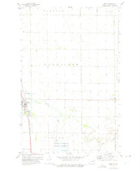
1973 Map of Minto
USGS Topo · Published 1975About this map
The Forest River winds through this Walsh County landscape, defining the agricultural and natural character of the region in the early 1970s. The settlement of Minto serves as a primary hub along the Burlington Northern railroad line, while the smaller community of Warsaw sits further east. Local history and genealogy interests are well-represented by the St Patrick Cem and Sacred Heart Cem, indicating the centered role of these parishes in the rural community. To the south, the Ardoch National Wildlife Refuge and Lake Ardoch mark a significant area of conservation and water management. The map reveals a highly structured township system, with boundaries for Harriston, Pulaski, and Walshville clearly delineated across the prairie. A Gaging Station and Sewage Disposal Ponds point to the technical infrastructure supporting these Red River Valley communities.
Find a feature on this map
18 named features on this map. Tap any name to fly to it.
Don’t see what you’re looking for? This feature index may not catch every label — zoom into the map to look around manually.
Map Details
Editions of this 1973 Minto Map
This is the sole edition of this map. No revisions or reprints were ever made.
Other maps of this area

1918 · Acton
USGS Topo · 1:62,500

1926 · Ardoch
USGS Topo · 1:62,500

1943 · Grafton
USGS Topo · 1:62,500

1952 · Thief River Falls
USGS Topo · 1:250,000

1956 · Thief River Falls
USGS Topo · 1:250,000

1957 · Thief River Falls
USGS Topo · 1:250,000

1960 · Grafton
USGS Topo · 1:24,000
1960 · Big Woods NW
USGS Topo · 1:24,000
1960 · Oakwood
USGS Topo · 1:24,000
1963 · Forest River
USGS Topo · 1:24,000