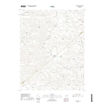
2019 Map of Mintonville
USGS Topo · Published 2019About this map
Mintonville and Argyle sit along the winding path of S KY 837 in this detailed survey of the rural landscape where the Casey County and Pulaski County lines meet. The terrain is defined by a dense network of high ground, including South Fork Ridge, Shady Grove Ridge, and Hughes Ridge, which separate the headwaters of numerous creeks. The map is a valuable resource for genealogists, as it documents a high concentration of family and community burial grounds such as Watson Chapel Cem, Grave Hill Cem, and Phelps Cem. Notable elevations like Green River Knob and Henson Knob punctuate the landscape, overlooking the drainages of Henson Cr and Turkey Cr. In the northeastern corner, the settlement of Bethelridge stands near Rocky Knob, while the community of Pointer anchors the southern reaches near Hickory Nut Ridge.
Find a feature on this map
104 named features on this map. Tap any name to fly to it.
Don’t see what you’re looking for? This feature index may not catch every label — zoom into the map to look around manually.
Map Details
Editions of this 2019 Mintonville Map
This is the sole edition of this map. No revisions or reprints were ever made.
Other maps of this area

1935 · Somerset
USGS Topo · 1:62,500

1952 · Eubank
USGS Topo · 1:24,000

1952 · Liberty
USGS Topo · 1:24,000

1952 · Yosemite
USGS Topo · 1:24,000

1953 · Phil
USGS Topo · 1:24,000

1953 · Mintonville
USGS Topo · 1:24,000

1954 · Delmer
USGS Topo · 1:24,000

1954 · Science Hill
USGS Topo · 1:24,000

1954 · Eli
USGS Topo · 1:24,000
1954 · Faubush
USGS Topo · 1:24,000