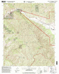
1995 Map of Miranda Pine Mountain
USGS Topo · Published 2000About this map
The Sierra Madre Mountains dominate this high-elevation landscape in the Los Padres National Forest, where the terrain transitions sharply from the Cuyama Valley into the protected San Rafael Wilderness. Local life in the mid-1990s is centered around established outposts like Gifford Ranch and Rock Front Ranch, while the interior remains accessible primarily via the Sierra Madre Road and historical landmarks like the Davis Cabin.
Find a feature on this map
51 named features on this map. Tap any name to fly to it.
Don’t see what you’re looking for? This feature index may not catch every label — zoom into the map to look around manually.
Map Details
Editions of this 1995 Miranda Pine Mountain Map
This is the sole edition of this map. No revisions or reprints were ever made.
Other maps of this area

1902 · Santa Ynez
USGS Topo · 1:125,000

1905 · Santa Ynez
USGS Topo · 1:125,000

1905 · Lompoc
USGS Topo · 1:125,000

1912 · McKittrick
USGS Topo · 1:125,000

1937 · Branch Mtn
USGS Topo · 1:48,000

1941 · Caliente Mountain
USGS Topo · 1:62,500

1941 · McPherson Peak
USGS Topo · 1:62,500

1942 · Lompoc
USGS Topo · 1:125,000

1942 · Branch Mountain
USGS Topo · 1:62,500

1942 · Caliente Mtn
USGS Topo · 1:62,500