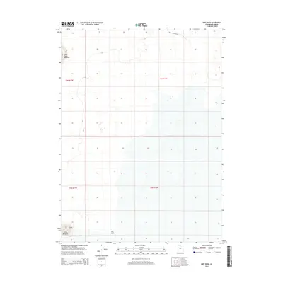
2014 Map of Miry Wash
USGS Topo · Published 2014About this map
Silver Island Mountains and the Little Pigeon Mountains define this arid landscape in the northwest corner of the state. The terrain is characterized by a high-desert basin where the ephemeral drainage of Miry Wash cuts through the flats between these isolated ranges. To the southwest, the distinctive landform of Crater Island emerges from the surrounding basin, marked by the 4250-foot contour line that traces much of the local topography. This 2014 survey reflects a largely undeveloped region, showing only a sparse network of pathways such as Little Pigeon Rd cutting across the northern reaches. The map provides a precise look at the township and range boundaries including t6n r17w, t6n r16w, t5n r17w, and t5n r16w, which help orient researchers to specific sections of this remote desert environment.
Find a feature on this map
9 named features on this map. Tap any name to fly to it.
Don’t see what you’re looking for? This feature index may not catch every label — zoom into the map to look around manually.
Map Details
Editions of this 2014 Miry Wash Map
This is the sole edition of this map. No revisions or reprints were ever made.
Other maps of this area

1954 · Brigham City
USGS Topo · 1:250,000

1958 · Brigham City
USGS Topo · 1:250,000

1962 · Brigham City
USGS Topo · 1:250,000

1967 · Pigeon Mountain
USGS Topo · 1:24,000

1967 · Lemay Island
USGS Topo · 1:24,000

1970 · Crater Island
USGS Topo · 1:24,000

1983 · Jackson
USGS Topo · 1:24,000
1983 · Lucin 4 SW
USGS Topo · 1:24,000

1983 · Bovine SE
USGS Topo · 1:24,000

1983 · Lucin 4 NE
USGS Topo · 1:24,000