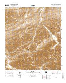
2015 Map of Misheguk Mountain C-5 SW
USGS Topo · Published 2015About this map
Noatak National Preserve encompasses the southern portion of this Arctic landscape, where the terrain is defined by complex contour elevations and the presence of Spike Creek. This remote section of the De Long Mountains reflects the pristine wilderness of the North Slope at the beginning of the twenty-first century, showing a land almost entirely devoid of human infrastructure. The survey focuses on the natural drainage patterns and the transition between high mountain ridges and the watercourses that carve through them. For researchers, this map provides a precise record of the hydrography and topography of the t11s r42w and t11s r43w township divisions within a protected national wilderness area.
Find a feature on this map
8 named features on this map. Tap any name to fly to it.
Don’t see what you’re looking for? This feature index may not catch every label — zoom into the map to look around manually.
Map Details
Editions of this 2015 Misheguk Mountain C-5 SW Map
This is the sole edition of this map. No revisions or reprints were ever made.
Other maps of this area

1951 · De Long Mountains
USGS Topo · 1:250,000

1951 · Misheguk Mountain
USGS Topo · 1:250,000

1955 · De Long Mountains
USGS Topo · 1:250,000
1955 · De Long Mountains C-1
USGS Topo · 1:63,360
1955 · De Long Mountains B-1
USGS Topo · 1:63,360

1956 · Misheguk Mountain
USGS Topo · 1:250,000

1965 · De Long Mountains
USGS Topo · 1:250,000
1984 · Misheguk Mountain C-5
USGS Topo · 1:63,360
1990 · Misheguk Mountain B-5
USGS Topo · 1:63,360
2014 · Misheguk Mountain C-5 SE
USGS Topo · 1:25,000