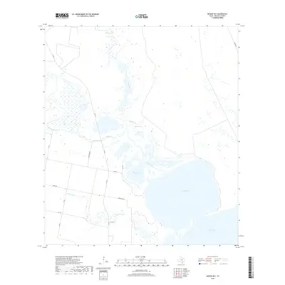
2019 Map of Mission Bay
USGS Topo · Published 2019About this map
Mission River winds through the coastal lowlands of Refugio County, depositing sediment into the expansive Mission Lake and Mission Bay complex. This hydrological network defines the local geography, where freshwater systems like Melon Creek and Mullens Bayou meet the brackish waters of Copano Bay. The map reveals a landscape managed for transit and drainage, characterized by rural routes such as Mission River Rd and Cemetery Rd that navigate the marshy terrain. Small landmarks like Hynes Springs and the named area of Rancho Grande offer specific points of interest for those tracing the historical footprint of ranching and water access in this coastal Texas region during the late twenty-first century.
Find a feature on this map
19 named features on this map. Tap any name to fly to it.
Don’t see what you’re looking for? This feature index may not catch every label — zoom into the map to look around manually.
Map Details
Editions of this 2019 Mission Bay Map
This is the sole edition of this map. No revisions or reprints were ever made.
Other maps of this area

1953 · Beeville
USGS Topo · 1:250,000

1954 · Rockport
USGS Topo · 1:62,500

1954 · Woodsboro
USGS Topo · 1:62,500

1954 · Vidaurri
USGS Topo · 1:62,500

1954 · Refugio
USGS Topo · 1:62,500

1956 · Beeville
USGS Topo · 1:250,000

1960 · Beeville
USGS Topo · 1:250,000

1978 · Woodsboro
USGS Topo · 1:24,000
1978 · Twin Mott Lake
USGS Topo · 1:24,000
1979 · Mission Bay
USGS Topo · 1:24,000