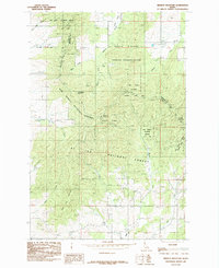
1985 Map of Mission Mountain
USGS Topo · Published 1985About this map
Mary Minerva Mc Croskey Memorial State Park anchors this mid-1980s survey, straddling the high ridges where the Latah and Benewah County line meets. The landscape is defined by the complex drainage systems of the St Joe National Forest, where the various forks of Pine Creek and Silver Creek carve through the timbered slopes. This era of land management is captured in detail, showing the intersection of state park land with the Coeur D'Alene Indian Reservation and federal forest territory. Notable elevations like Huckleberry Mountain, Mission Mountain, and Mineral Mountain provide a clear view of the topographical challenges for early road building and forest service access. The map also records localized features like Mountain Jack Lane, offering a specific look at rural access points during this period of the Idaho Panhandle's history.
Find a feature on this map
21 named features on this map. Tap any name to fly to it.
Don’t see what you’re looking for? This feature index may not catch every label — zoom into the map to look around manually.
Map Details
Editions of this 1985 Mission Mountain Map
This is the sole edition of this map. No revisions or reprints were ever made.
Other maps of this area

1903 · Oakesdale
USGS Topo · 1:125,000

1905 · Oakesdale
USGS Topo · 1:125,000

1910 · Pullman
USGS Topo · 1:125,000

1955 · Pullman
USGS Topo · 1:250,000

1955 · Spokane
USGS Topo · 1:250,000

1957 · Tensed
USGS Topo · 1:62,500

1958 · Spokane
USGS Topo · 1:250,000

1958 · Pullman
USGS Topo · 1:250,000

1960 · Potlatch
USGS Topo · 1:62,500

1964 · Tekoa
USGS Topo · 1:24,000