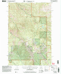
2003 Map of Mission Peak
USGS Topo · Published 2006About this map
Mission Ridge serves as the dominant high-country feature along the Chelan and Kittitas county line, defined by its complex drainage network and high-elevation landmarks. The landscape is heavily managed as part of the Wenatchee National Forest and the Colockum State Wildlife Area, reflecting a 21st-century balance of recreation and conservation. Notable human footprints include the Beehive Lookout and Naneum Lookout, alongside the recreational infrastructure of the Mission Ridge Winter Sports Area. This area transitions from the hydro-resources of Beehive Reservoir and Beehive Spring to the higher peaks, including the 6,876-foot Mission Peak. The presence of Dutch Settlement Creek suggests the enduring legacy of early settlers who navigated these canyons, while the Wenatchee Mountain Communication Facility represents modern technical utility in a remote environment.
Find a feature on this map
34 named features on this map. Tap any name to fly to it.
Don’t see what you’re looking for? This feature index may not catch every label — zoom into the map to look around manually.
Map Details
Editions of this 2003 Mission Peak Map
This is the sole edition of this map. No revisions or reprints were ever made.
Other maps of this area

1897 · Mount Stuart
USGS Topo · 1:125,000

1902 · Mount Stuart
USGS Topo · 1:125,000

1913 · Wenatchee
USGS Topo · 1:62,500

1915 · Wenatchee
USGS Topo · 1:62,500

1920 · Colockum Pass
USGS Topo · 1:125,000

1922 · Colockum Pass
USGS Topo · 1:125,000

1957 · Wenatchee
USGS Topo · 1:250,000

1958 · Thorp
USGS Topo · 1:62,500

1961 · Liberty
USGS Topo · 1:62,500

1966 · Wenatchee
USGS Topo · 1:24,000