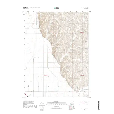
2018 Map of Missouri Valley NW
USGS Topo · Published 2018About this map
The settlement of Magnolia and the nearby village of Calhoun anchor this study of the western Iowa landscape, where the abrupt transition from the Loess Hills to the Missouri River floodplain is clearly defined. The terrain is bifurcated by the winding path of Ia 183, which follows the base of the bluffs. To the east, the deeply eroded hills are marked by a dense network of family-named roads and trails, including Loess Hills Trl and Melody Oaks Trl, while the western flats are dominated by an engineered drainage system. This hydraulic infrastructure, featuring the E Soldier Ditch, Nelson Ditch, and Modale Ditch, illustrates the extensive 20th-century efforts to reclaim the bottomlands for agriculture. Genealogists will find the exact locations of Magnolia Cem and Calhoun Cem preserved alongside the natural courses of Allen Creek and Steer Creek.
Find a feature on this map
56 named features on this map. Tap any name to fly to it.
Don’t see what you’re looking for? This feature index may not catch every label — zoom into the map to look around manually.
Map Details
Editions of this 2018 Missouri Valley NW Map
This is the sole edition of this map. No revisions or reprints were ever made.
Other maps of this area

1954 · Omaha
USGS Topo · 1:250,000

1955 · Fremont
USGS Topo · 1:250,000

1957 · Fremont
USGS Topo · 1:250,000

1957 · Omaha
USGS Topo · 1:250,000

1958 · Omaha
USGS Topo · 1:250,000

1958 · Fremont
USGS Topo · 1:250,000

1970 · Little Sioux
USGS Topo · 1:24,000

1970 · Logan
USGS Topo · 1:24,000
1970 · Missouri Valley
USGS Topo · 1:24,000

1970 · Mondamin
USGS Topo · 1:24,000