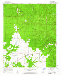
1960 Map of Mist
USGS Topo · Published 1961About this map
Bearhouse Prairie and the surrounding timberlands of Ashley County define this landscape, where the Missouri Pacific railroad cuts a diagonal path toward the settlement of Mist. The map reveals a rural economy transitioning between open prairie and the dense creek bottoms of Bearhouse Creek and Chemin-a-Haut Creek. Numerous water-resource markers and a Lookout Tower underscore the region's focus on land management and fire prevention during the early 1960s.
Find a feature on this map
25 named features on this map. Tap any name to fly to it.
Don’t see what you’re looking for? This feature index may not catch every label — zoom into the map to look around manually.
Map Details
Editions of this 1960 Mist Map
2 editions found
Other maps of this area

1935 · Mist
USGS Topo · 1:62,500

1935 · Wilmot
USGS Topo · 1:62,500

1952 · Fountain Hill
USGS Topo · 1:24,000

1953 · Greenwood
USGS Topo · 1:250,000

1956 · Greenwood
USGS Topo · 1:250,000

1960 · Snyder
USGS Topo · 1:24,000

1960 · Mist
USGS Topo · 1:62,500

1960 · Wilmot
USGS Topo · 1:62,500
1960 · Portland
USGS Topo · 1:24,000

1960 · Wilmot NW
USGS Topo · 1:24,000