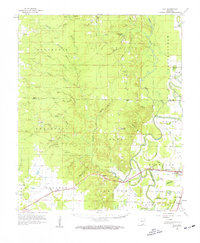
1960 Map of Mist
USGS Topo · Published 1961About this map
Missouri Pacific rails traverse the southern lowlands of Ashley County, connecting the settlements of Snyder, Mist, and Montrose during the early 1960s. The landscape is defined by the transition from the rolling timberlands of the Bearhouse and Collins townships to the alluvial basins of the Bartholomew area. Notable for its high density of family and community landmarks, the map shows numerous rural institutions including Jordan Cem, Judkins Cem, and Mt Olive Ch. The drainage patterns are intricate, with Bearhouse Creek and Cutoff Creek feeding into the swampy breaks of the east, where Holloway Brake and New Providence Brake indicate a terrain dominated by seasonal overflow and wetlands. This survey provides a precise look at the rural infrastructure of the era, from the Lookout Tower near the Drew County line to the remote church at Berea.
Find a feature on this map
74 named features on this map. Tap any name to fly to it.
Don’t see what you’re looking for? This feature index may not catch every label — zoom into the map to look around manually.
Map Details
Editions of this 1960 Mist Map
2 editions found

Other maps of this area

1935 · Mist
USGS Topo · 1:62,500

1935 · Wilmot
USGS Topo · 1:62,500

1935 · Cominto
USGS Topo · 1:62,500

1936 · McGehee
USGS Topo · 1:62,500

1936 · Eudora
USGS Topo · 1:62,500

1936 · Lake Village
USGS Topo · 1:62,500

1937 · McGehee
USGS Topo · 1:62,500

1952 · Fountain Hill
USGS Topo · 1:24,000

1953 · Greenwood
USGS Topo · 1:250,000

1955 · Lake Village
USGS Topo · 1:62,500