
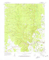
1960 Map of Mist
USGS Topo · Published 1961About this map
Bayou Bartholomew snakes through the eastern reach of this delta landscape, defining a terrain of cypress brakes, sloughs, and oxbow lakes like Lloyds Lake. In the early 1960s, this region of Ashley County was anchored by the Missouri Pacific railroad, which connected the settlements of Montrose, Snyder, and Mist. The map documents a rural society built around small community centers and family landmarks, with numerous country churches such as Bethlehem Ch and New Providence Ch serving the area. The prevalence of named cemeteries, including Griswould Cem and Townsend Cem, provides a detailed record of local family history near the Drew and Ashley County line. In the central woods, the Lookout Tower stands as a sentinel over the drainages of Bearhouse Creek and Wolf Creek, while to the south, the landscape opens into the level expanses of the Prairie and Banner districts.
Find a feature on this map
70 named features on this map. Tap any name to fly to it.
Don’t see what you’re looking for? This feature index may not catch every label — zoom into the map to look around manually.
Map Details
Editions of this 1960 Mist Map
2 editions found
Other maps of this area

1935 · Mist
USGS Topo · 1:62,500

1935 · Wilmot
USGS Topo · 1:62,500

1935 · Cominto
USGS Topo · 1:62,500

1936 · McGehee
USGS Topo · 1:62,500

1936 · Eudora
USGS Topo · 1:62,500

1936 · Lake Village
USGS Topo · 1:62,500

1937 · McGehee
USGS Topo · 1:62,500

1952 · Fountain Hill
USGS Topo · 1:24,000

1953 · Greenwood
USGS Topo · 1:250,000

1955 · Lake Village
USGS Topo · 1:62,500