
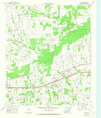
1963 Map of Mitchell Creek
USGS Topo · Published 1964About this map
The Sulphur River and its complex network of tributaries define the landscape of this Northeast Texas quadrangle in the early 1960s. The northern reaches show the South Sulphur River winding through its Old Channel, while the Shell Oil Field marks a significant industrial footprint in the center of the sheet. Small agricultural communities and rural junctions like Eureka and Hagansport serve as local hubs, connected by a web of light-duty roads and pipelines that cut through the timbered creek bottoms.
Find a feature on this map
17 named features on this map. Tap any name to fly to it.
Don’t see what you’re looking for? This feature index may not catch every label — zoom into the map to look around manually.
Map Details
Editions of this 1963 Mitchell Creek Map
This is the sole edition of this map. No revisions or reprints were ever made.
Other maps of this area

1953 · Texarkana
USGS Topo · 1:250,000

1956 · Texarkana
USGS Topo · 1:250,000

1962 · Sulphur Bluff
USGS Topo · 1:24,000

1963 · Minter
USGS Topo · 1:24,000

1963 · Cunningham
USGS Topo · 1:24,000

1964 · Mount Vernon
USGS Topo · 1:24,000

1964 · Saltillo
USGS Topo · 1:24,000

1964 · Hagansport
USGS Topo · 1:24,000

1964 · Bogata
USGS Topo · 1:24,000
1965 · Dike
USGS Topo · 1:24,000