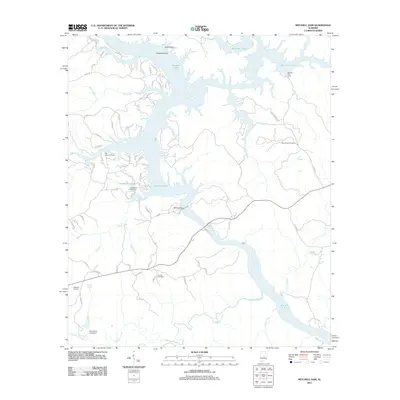
2011 Map of Mitchell Dam
USGS Topo · Published 2011About this map
Mitchell Lake dominates this central Alabama landscape, its serpentine shoreline and numerous inlets defining the character of the region. The map centers on the massive Mitchell Dam across the Coosa River, a critical piece of infrastructure that regulates the lake's flow. Further upstream, smaller impoundments like Livingston Lake, held back by the Livingston Lake Dam, and the Woodward Lake Dam illustrate a landscape heavily modified for water management and recreation. The area is dotted with family-history landmarks, including the Old Salem Cemetery and Mount Sinai Cemetery, which speak to the deep-rooted rural communities that preceded the modern lakefront. Small-scale commerce is represented by Barretts Fish Camp, highlighting the transition from traditional agriculture to a recreation-based economy centered on the water.
Find a feature on this map
68 named features on this map. Tap any name to fly to it.
Don’t see what you’re looking for? This feature index may not catch every label — zoom into the map to look around manually.
Map Details
Editions of this 2011 Mitchell Dam Map
This is the sole edition of this map. No revisions or reprints were ever made.
Other maps of this area

1891 · Clanton
USGS Topo · 1:125,000

1901 · Wetumpka
USGS Topo · 1:125,000

1903 · Wetumpka
USGS Topo · 1:125,000

1953 · Montgomery
USGS Topo · 1:250,000

1956 · Montgomery
USGS Topo · 1:250,000

1957 · Montgomery
USGS Topo · 1:250,000

1959 · Billingsley
USGS Topo · 1:62,500

1959 · Elmore
USGS Topo · 1:62,500

1971 · Richville
USGS Topo · 1:24,000
1971 · Mitchell Dam NW
USGS Topo · 1:24,000