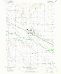
1963 Map of Mitchell
USGS Topo · Published 1973About this map
The North Platte River carves a fertile path through Scotts Bluff County, defining the agricultural and logistical layout of the region. Irrigation infrastructure is central to the landscape, with the Tri-State Canal, Enterprise Canal, and Gering Canal diverting water to sustain local farms. The town of Mitchell serves as the primary hub, situated north of the river near the County Fairground and Mitchell Airport, while South Mitchell and Haig anchor the southern agricultural lands.
Find a feature on this map
33 named features on this map. Tap any name to fly to it.
Don’t see what you’re looking for? This feature index may not catch every label — zoom into the map to look around manually.
Map Details
Editions of this 1963 Mitchell Map
2 editions found
Other maps of this area

1898 · Scotts Bluff
USGS Topo · 1:125,000

1899 · Whistle Creek
USGS Topo · 1:125,000

1954 · Scottsbluff
USGS Topo · 1:250,000

1955 · Alliance
USGS Topo · 1:250,000

1957 · Alliance
USGS Topo · 1:250,000

1958 · Alliance
USGS Topo · 1:250,000

1958 · Scottsbluff
USGS Topo · 1:250,000

1960 · Stegall
USGS Topo · 1:24,000

1963 · Scottsbluff South
USGS Topo · 1:24,000

1963 · Mitchell
USGS Topo · 1:24,000