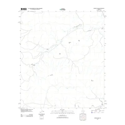
2012 Map of Mitre Peak
USGS Topo · Published 2012About this map
Mitre Peak rises as the central landmark of this high-desert terrain, anchoring a landscape defined by significant elevation changes and seasonal drainage systems. The northern reaches are characterized by the winding path of Musquiz Cr and the many branches of Barillos Cr, which flow through features like Box Canyon and near Tippett Springs. This modern-era survey shows the sparse development typical of the Trans-Pecos, with human presence concentrated at Mitre Peak Camp and the small cluster at Sunny Glen in the southeast corner. Transportation is limited to functional routes like Ranch Road 1837 and specialized access ways such as Wagon Rd and Trail Rd. The map also captures several distinctive geological formations beyond the main peak, including the Twin Mountains, Castle Rock, and the isolated rise known as The Haystack.
Find a feature on this map
22 named features on this map. Tap any name to fly to it.
Don’t see what you’re looking for? This feature index may not catch every label — zoom into the map to look around manually.
Map Details
Editions of this 2012 Mitre Peak Map
This is the sole edition of this map. No revisions or reprints were ever made.
Other maps of this area

1894 · Fort Davis
USGS Topo · 1:125,000

1895 · Alpine
USGS Topo · 1:125,000

1897 · Fort Davis
USGS Topo · 1:125,000

1954 · Fort Stockton
USGS Topo · 1:250,000

1958 · Fort Stockton
USGS Topo · 1:250,000
1972 · Fort Davis SE
USGS Topo · 1:24,000

1972 · Alpine North
USGS Topo · 1:24,000
1972 · Fort Davis
USGS Topo · 1:24,000

1972 · Paisano
USGS Topo · 1:24,000

1972 · Mitre Peak
USGS Topo · 1:24,000