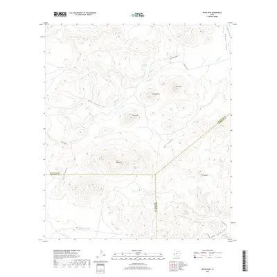
2019 Map of Mitre Peak
USGS Topo · Published 2019About this map
Mitre Peak and Antelope Peak dominate the high-elevation landscape of the Trans-Pecos region, where three West Texas counties converge. This 2019 survey captures the rugged drainage patterns of Musquiz Canyon and Box Canyon, alongside smaller landmarks like Castle Rock and The Haystack. The map provides essential detail for researchers studying the arid topography and sparse water sources of the Big Bend area, including Tippett Springs and Ramirez Tank. Modern transport corridors such as Ranch Rd 1837 and Mitre Peak Camp Rd weave between the peaks, while family-named features like Sunny Glen and Franks Canyon suggest the long-standing ranching history of the area. The three-way intersection of the Jeff Davis, Presidio, and Brewster county lines creates a unique geopolitical boundary point in the center of the sheet.
Find a feature on this map
25 named features on this map. Tap any name to fly to it.
Don’t see what you’re looking for? This feature index may not catch every label — zoom into the map to look around manually.
Map Details
Editions of this 2019 Mitre Peak Map
This is the sole edition of this map. No revisions or reprints were ever made.
Other maps of this area

1894 · Fort Davis
USGS Topo · 1:125,000

1895 · Alpine
USGS Topo · 1:125,000

1897 · Fort Davis
USGS Topo · 1:125,000

1954 · Fort Stockton
USGS Topo · 1:250,000

1958 · Fort Stockton
USGS Topo · 1:250,000
1972 · Fort Davis SE
USGS Topo · 1:24,000

1972 · Alpine North
USGS Topo · 1:24,000
1972 · Fort Davis
USGS Topo · 1:24,000

1972 · Paisano
USGS Topo · 1:24,000

1972 · Mitre Peak
USGS Topo · 1:24,000