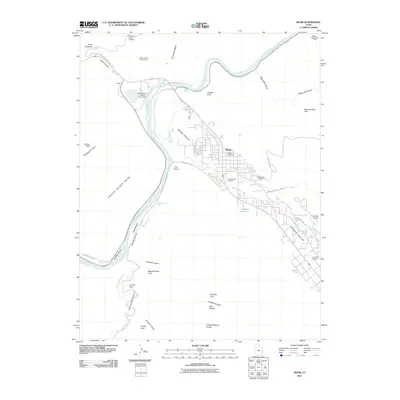
2011 Map of Moab
USGS Topo · Published 2011About this map
Moab Valley serves as a dramatic corridor for the Colorado River as it winds through this sandstone landscape in the early twenty-first century. The city of Moab is centered near the confluence of Mill Creek and Pack Creek, showing a dense grid of streets that transition into the wider agricultural and residential stretches of Spanish Valley. Evidence of the region's industrial and environmental history is visible at the Atlas Mineral Tailings Pond Dam along the riverbanks, while the surrounding desert is defined by its remarkable geological features, including Corona Arch, Morning Glory Arch, and Pritchett Natural Bridge. Local landmarks such as the Moab Post Office and Grand Valley Cemetery anchor the community, while the Sunbird Airport and South Park Avenue Trailhead highlight the area's role as a base for modern exploration and travel.
Find a feature on this map
49 named features on this map. Tap any name to fly to it.
Don’t see what you’re looking for? This feature index may not catch every label — zoom into the map to look around manually.
Map Details
Editions of this 2011 Moab Map
This is the sole edition of this map. No revisions or reprints were ever made.
Other maps of this area

1885 · La Sal
USGS Topo · 1:250,000

1952 · Moab 4 NW
USGS Topo · 1:24,000

1952 · Moab 4 SW
USGS Topo · 1:24,000

1954 · Mt Peale 2 NW
USGS Topo · 1:24,000

1954 · Carlisle 1 NE
USGS Topo · 1:24,000

1954 · Carlisle 1 NW
USGS Topo · 1:24,000

1954 · Mt. Waas 3 NW
USGS Topo · 1:24,000

1954 · Mt. Waas 3 SW
USGS Topo · 1:24,000

1954 · La Sal Junction
USGS Topo · 1:62,500

1954 · Castle Valley
USGS Topo · 1:62,500