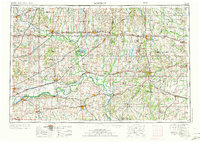
1954 Map of Moberly
USGS Topo · Published 1973About this map
The Missouri River cuts a wide path through the central Missouri landscape, shaping the development of river towns like Lexington, Boonville, and Glasgow. This mid-century survey illustrates the region's heavy reliance on both water and rail transportation, with the Burlington Northern RR and Norfolk and Western RR spiderwebbing across the plains to connect agriculture hubs like Moberly, Chillicothe, and Marshall.
Find a feature on this map
243 named features on this map. Tap any name to fly to it.
Don’t see what you’re looking for? This feature index may not catch every label — zoom into the map to look around manually.
Map Details
Editions of this 1954 Moberly Map
3 editions found

Other maps of this area

1885 · Warrensburg
USGS Topo · 1:125,000

1886 · Jefferson City
USGS Topo · 1:125,000

1887 · Harrisonville
USGS Topo · 1:125,000

1887 · Sedalia
USGS Topo · 1:125,000

1887 · Warrensburg
USGS Topo · 1:125,000

1888 · Boonville
USGS Topo · 1:125,000

1889 · Lexington
USGS Topo · 1:125,000

1890 · Mexico
USGS Topo · 1:125,000

1890 · Moberly
USGS Topo · 1:125,000

1890 · Glasgow
USGS Topo · 1:125,000