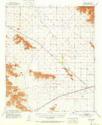
1951 Map of Mobile
USGS Topo · Published 1952About this map
The Butterfield Stage Route cuts a diagonal path across this desert landscape, tracing a historical corridor of travel through the heart of the Rainbow Valley. To the southwest, the Maricopa Mts rise sharply, balanced by the towering Sierra Estrella in the northeast, where the boundary of the Gila River Indian Reservation is established. The southern portion of the map is dominated by the industrial spine of the Southern Pacific railroad, which links the small settlements of Mobile, Shawmut, and Estrella (Siding). This mid-century survey captures an era when transportation was defined by both the legacy of the old stage lines and the active heavy rail network. Features such as a lone Cem near Mobile and a remote Airstrip in the valley floor indicate the sparse, specialized land use in this arid region, where life was tethered to the intermittent drainage of Waterman Wash.
Find a feature on this map
21 named features on this map. Tap any name to fly to it.
Don’t see what you’re looking for? This feature index may not catch every label — zoom into the map to look around manually.
Map Details
Editions of this 1951 Mobile Map
3 editions found

Other maps of this area

1912 · Phoenix
USGS Topo · 1:62,500

1913 · Maricopa
USGS Topo · 1:62,500

1914 · Phoenix
USGS Topo · 1:62,500

1915 · Maricopa
USGS Topo · 1:62,500

1946 · Antelope Peak
USGS Topo · 1:62,500

1946 · Avondale
USGS Topo · 1:62,500

1948 · Cashion
USGS Topo · 1:62,500

1948 · Antelope Peak
USGS Topo · 1:62,500

1951 · Estrella
USGS Topo · 1:62,500

1951 · Gila Bend
USGS Topo · 1:62,500