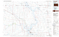
1985 Map of Mobridge
USGS Topo · Published 1985About this map
Standing Rock Indian Reservation dominates the western half of this mid-1980s survey, bisected by the wide expanse of Lake Oahe on the Missouri River. The landscape is a complex network of plateaus and drainages, where the Grand River meets the Missouri near Mobridge. This period of the mid-twentieth century shows a region defined by its memorials and diverse land management, featuring the St Elizabeth Mission Home and the Leavenworth Monument. Significant historical markers like Sitting Bulls Grave and the Sakakawea Monument are situated along the river bluffs, overlooking the reservoir. Transportation is anchored by the Burlington Northern railroad, which services river-adjacent settlements like McLaughlin and Wakpala. To the northeast, the Pocasse National Wildlife Refuge and various waterfowl production areas illustrate the importance of the Missouri flyway in this prairie environment.
Find a feature on this map
66 named features on this map. Tap any name to fly to it.
Don’t see what you’re looking for? This feature index may not catch every label — zoom into the map to look around manually.
Map Details
Editions of this 1985 Mobridge Map
2 editions found
Other maps of this area

1953 · Jamestown
USGS Topo · 1:250,000

1953 · McIntosh
USGS Topo · 1:250,000

1954 · Aberdeen
USGS Topo · 1:250,000

1954 · Bismarck
USGS Topo · 1:250,000

1956 · Aberdeen
USGS Topo · 1:250,000

1956 · Jamestown
USGS Topo · 1:250,000

1956 · Little Eagle SW
USGS Topo · 1:24,000

1956 · Wakpala NW
USGS Topo · 1:24,000

1956 · Little Eagle
USGS Topo · 1:24,000

1956 · Wakpala SE
USGS Topo · 1:24,000