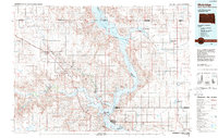
1985 Map of Mobridge
USGS Topo · Published 1988About this map
Standing Rock Indian Reservation occupies the western half of this mid-1980s survey, defined by the expansive waters of the Missouri River and Lake Oahe. The regional hub of Mobridge sits on the eastern shore, serving as a critical crossing point where the Burlington Northern railroad meets the water. The landscape is characterized by the transition from the river valley to the surrounding plains, punctuated by isolated landmarks like Lonesome Butte and Runaround Butte.
Find a feature on this map
57 named features on this map. Tap any name to fly to it.
Don’t see what you’re looking for? This feature index may not catch every label — zoom into the map to look around manually.
Map Details
Editions of this 1985 Mobridge Map
2 editions found
Other maps of this area

1953 · Jamestown
USGS Topo · 1:250,000

1953 · McIntosh
USGS Topo · 1:250,000

1954 · Aberdeen
USGS Topo · 1:250,000

1954 · Bismarck
USGS Topo · 1:250,000

1956 · Aberdeen
USGS Topo · 1:250,000

1956 · Jamestown
USGS Topo · 1:250,000

1956 · Little Eagle SW
USGS Topo · 1:24,000

1956 · Wakpala NW
USGS Topo · 1:24,000

1956 · Little Eagle
USGS Topo · 1:24,000

1956 · Wakpala SE
USGS Topo · 1:24,000